


lagnes

Stefvtt
User
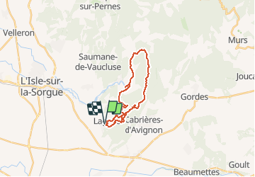

Length
23 km

Max alt
669 m

Uphill gradient
1006 m
Km-Effort
36 km

Min alt
117 m

Downhill gradient
1006 m
Boucle
Yes
Creation date :
2014-12-10 00:00:00.0
Updated on :
2014-12-10 00:00:00.0
3h00
Difficulty : Difficult

FREE GPS app for hiking
 SityTrail
IGN / Geographical institutes
SityTrail Plus
The world is yours!
About
Trail Mountain bike of 23 km to be discovered at Provence-Alpes-Côte d'Azur, Vaucluse, Lagnes. This trail is proposed by Stefvtt.
Positioning
Country:
France
Region :
Provence-Alpes-Côte d'Azur
Department/Province :
Vaucluse
Municipality :
Lagnes
Location:
Unknown
Start:(Dec)
Start:(UTM)
669768 ; 4862066 (31T) N.
Comments
la prise en main parait un peu complexe mais rapidement on découvre la simplicité d' utilisation. Domage qu'elle coûteuse.