


Montagne des auges

Chabard
User
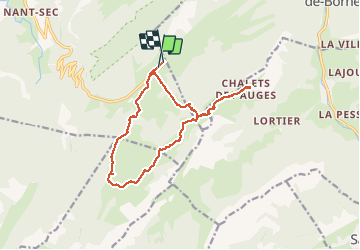

Length
14.7 km

Max alt
1797 m

Uphill gradient
545 m
Km-Effort
22 km

Min alt
1377 m

Downhill gradient
540 m
Boucle
No
Creation date :
2020-07-31 08:08:32.0
Updated on :
2020-07-31 15:14:57.343
6h24
Difficulty : Unknown

FREE GPS app for hiking
 SityTrail
IGN / Geographical institutes
SityTrail Plus
The world is yours!
About
Trail Walking of 14.7 km to be discovered at Auvergne-Rhône-Alpes, Upper Savoy, Fillière. This trail is proposed by Chabard.
Description
Montagne des auges et chapelle depuis le monument
Positioning
Country:
France
Region :
Auvergne-Rhône-Alpes
Department/Province :
Upper Savoy
Municipality :
Fillière
Location:
Thorens-Glières
Start:(Dec)
Start:(UTM)
293059 ; 5093617 (32T) N.
Comments