


rochehaut

DidierDHane
User
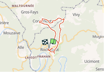

Length
12.3 km

Max alt
433 m

Uphill gradient
237 m
Km-Effort
15.4 km

Min alt
329 m

Downhill gradient
234 m
Boucle
Yes
Creation date :
2020-08-03 13:11:17.583
Updated on :
2020-08-03 14:55:23.163
1h21
Difficulty : Very easy

FREE GPS app for hiking
 SityTrail
IGN / Geographical institutes
SityTrail Plus
The world is yours!
About
Trail Mountain bike of 12.3 km to be discovered at Wallonia, Luxembourg, Bouillon. This trail is proposed by DidierDHane.
Description
Rochehaut
Positioning
Country:
Belgium
Region :
Wallonia
Department/Province :
Luxembourg
Municipality :
Bouillon
Location:
Rochehaut
Start:(Dec)
Start:(UTM)
644283 ; 5522987 (31U) N.
Comments