


territoire de l'ancienne commanderie de Puy de Noix

joebartwix
User
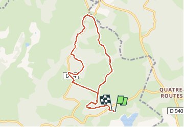

Length
9 km

Max alt
564 m

Uphill gradient
222 m
Km-Effort
12 km

Min alt
479 m

Downhill gradient
222 m
Boucle
Yes
Creation date :
2020-08-05 06:10:12.181
Updated on :
2020-08-05 08:52:25.655
1h38
Difficulty : Very easy

FREE GPS app for hiking
 SityTrail
IGN / Geographical institutes
SityTrail Plus
The world is yours!
About
Trail Nordic walking of 9 km to be discovered at New Aquitaine, Corrèze, Beynat. This trail is proposed by joebartwix.
Description
balisage jaune
Positioning
Country:
France
Region :
New Aquitaine
Department/Province :
Corrèze
Municipality :
Beynat
Location:
Unknown
Start:(Dec)
Start:(UTM)
402712 ; 4998350 (31T) N.
Comments