


Correze - Servieres-le-Chateau Camping du lac de Feyt 16km 100m

RandoVal
User
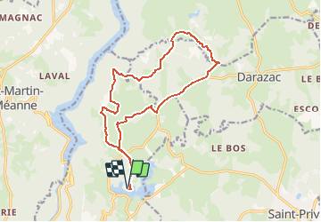

Length
16.5 km

Max alt
563 m

Uphill gradient
305 m
Km-Effort
21 km

Min alt
465 m

Downhill gradient
301 m
Boucle
Yes
Creation date :
2020-08-07 15:33:56.044
Updated on :
2020-08-07 15:40:18.604
--
Difficulty : Unknown

FREE GPS app for hiking
 SityTrail
IGN / Geographical institutes
SityTrail Plus
The world is yours!
About
Trail Walking of 16.5 km to be discovered at New Aquitaine, Corrèze, Servières-le-Château. This trail is proposed by RandoVal.
Description
Boucle en Xaintrie, départ et stationnement au camping du lac de Feyt, sens horaire.
Positioning
Country:
France
Region :
New Aquitaine
Department/Province :
Corrèze
Municipality :
Servières-le-Château
Location:
Unknown
Start:(Dec)
Start:(UTM)
424034 ; 4999471 (31T) N.
Comments