


lacs

Nicolas_Dec
User
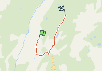

Length
3.9 km

Max alt
2441 m

Uphill gradient
102 m
Km-Effort
5.4 km

Min alt
2336 m

Downhill gradient
129 m
Boucle
No
Creation date :
2020-08-03 08:21:42.712
Updated on :
2020-08-09 13:45:50.661
2h00
Difficulty : Very easy

FREE GPS app for hiking
 SityTrail
IGN / Geographical institutes
SityTrail Plus
The world is yours!
About
Trail Walking of 3.9 km to be discovered at Auvergne-Rhône-Alpes, Savoy, Val-Cenis. This trail is proposed by Nicolas_Dec.
Positioning
Country:
France
Region :
Auvergne-Rhône-Alpes
Department/Province :
Savoy
Municipality :
Val-Cenis
Location:
Termignon
Start:(Dec)
Start:(UTM)
329290 ; 5022604 (32T) N.
Comments