Trail Walking Mandailles-Saint-Julien - Col du perthus puy Griou - Photo
 marcagif
marcagif

User

© OpenStreetMap contributors
Length
Length
15.2 km
Max alt
Max alt
1658 m
Uphill gradient
Uphill gradient
605 m
Km-Effort
Km-Effort  
23 km
Min alt
Min alt
1304 m
Downhill gradient
Downhill gradient
609 m
Boucle
Boucle
Yes
Creation date :
2020-08-11 07:11:03.979
Updated on :
2020-08-11 13:05:18.206

(0 Reviews)

Walking
Walking
5h33
Difficulty : Medium

Scan this QR Code to open this trail in the SityTrail application

FREE GPS app for hiking

Logo SityTrail SityTrail

IGN / Geographical institutes

Download SityTrail from the App Store Download SityTrail from Google Play

Logo SityTrail SityTrail World

The world is yours!

Download SityTrail from the App Store Download SityTrail from Google Play Download SityTrail on Huawei AppGallery

About

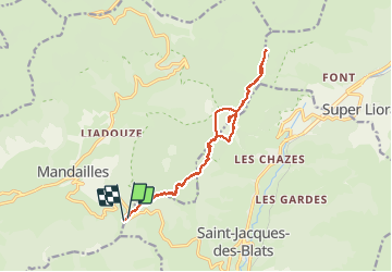
Trail Walking of 15.2 km to be discovered at Auvergne-Rhône-Alpes, Cantal, Mandailles-Saint-Julien. This trail is proposed by marcagif.

Description

départ du col vers le sommet do Griou puis vers le col donnant sur le Lioran

Elevation profile

Photos

Positioning

Country:
France
Region :
Auvergne-Rhône-Alpes
Department/Province :
Cantal
Municipality :
Mandailles-Saint-Julien
Location:
Unknown
Start:(UTM)
474352 ; 4989533 (31T) N.

Trails nearby

Trail Walking Thiézac - La Porte du Lion - Thiézac - Photo
Walking
tracegps

Walking

Medium
(2)
Thiézac, Auvergne-Rhône-Alpes, Cantal, France
6.6 km | 10.5 km-effort
3h 0min
Yes
Trail Walking Mandailles-Saint-Julien - L'Elancèze - Photo
Walking
tracegps

Walking

Difficult
(1)
Mandailles-Saint-Julien, Auvergne-Rhône-Alpes, Cantal, France
12.8 km | 24 km-effort
5h 0min
Yes
Trail Walking Laveissière - le Peyre Arse - Le Lioran - Photo
Walking
tracegps

Walking

Difficult
(1)
Laveissière, Auvergne-Rhône-Alpes, Cantal, France
11.2 km | 19.4 km-effort
4h 0min
No
Trail Walking Laveissière - Lioran 2023-08-18 Col de Rombière Col du Pertus A/R - Photo
Walking
marionneau

Walking

Easy
(1)
Laveissière, Auvergne-Rhône-Alpes, Cantal, France
12.5 km | 18.8 km-effort
4h 14min
Yes
Trail Walking Laveissière - Lioran 2023-08-09 Puy de Seycheuse - Photo
Walking
marionneau

Walking

Very difficult
(1)
Laveissière, Auvergne-Rhône-Alpes, Cantal, France
13.9 km | 23 km-effort
5h 20min
Yes
Trail Walking Thiézac - La porte du Lion - Thiézac - Photo
Walking
tracegps

Walking

Medium
(2)
Thiézac, Auvergne-Rhône-Alpes, Cantal, France
7.6 km | 11.5 km-effort
3h 30min
Yes
Trail Walking Laveissière - Lioran 2023-08-09 Puy de Seycheuse  - Photo
Walking
marionneau

Walking

Medium
Laveissière, Auvergne-Rhône-Alpes, Cantal, France
14.8 km | 25 km-effort
4h 34min
Yes
Trail Walking Laveissière - Font de cere puy griou  - Photo
Walking
GUIDE
antignacs

Walking

Medium
Laveissière, Auvergne-Rhône-Alpes, Cantal, France
13.6 km | 23 km-effort
5h 32min
Yes
Trail Hybrid bike Mandailles-Saint-Julien - Tournemire  - Photo
Hybrid bike
nadd73

Hybrid bike

Medium
Mandailles-Saint-Julien, Auvergne-Rhône-Alpes, Cantal, France
39 km | 50 km-effort
3h 2min
No


Close
My subscriptions