


L'Eygaye / st jean Monclar

mthomas30
User
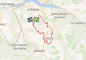

Length
27 km

Max alt
1414 m

Uphill gradient
1073 m
Km-Effort
42 km

Min alt
1114 m

Downhill gradient
1076 m
Boucle
Yes
Creation date :
2020-08-13 07:22:05.946
Updated on :
2020-08-23 19:55:21.632
4h05
Difficulty : Difficult

FREE GPS app for hiking
 SityTrail
IGN / Geographical institutes
SityTrail Plus
The world is yours!
About
Trail Mountain bike of 27 km to be discovered at Provence-Alpes-Côte d'Azur, Alpes-de-Haute-Provence, Ubaye-Serre-Ponçon. This trail is proposed by mthomas30.
Description
Portage pour monter à la Salette.
Positioning
Country:
France
Region :
Provence-Alpes-Côte d'Azur
Department/Province :
Alpes-de-Haute-Provence
Municipality :
Ubaye-Serre-Ponçon
Location:
La Bréole
Start:(Dec)
Start:(UTM)
284794 ; 4922550 (32T) N.
Comments