


orgérés enfants

JPS73
User
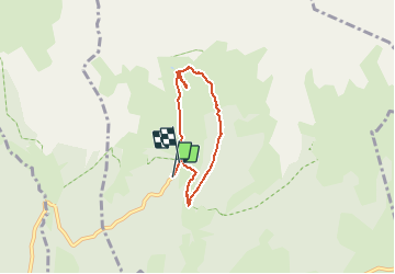

Length
4.9 km

Max alt
2067 m

Uphill gradient
200 m
Km-Effort
7.5 km

Min alt
1891 m

Downhill gradient
192 m
Boucle
Yes
Creation date :
2020-08-16 09:09:51.666
Updated on :
2020-08-16 14:00:23.466
1h45
Difficulty : Very easy

FREE GPS app for hiking
 SityTrail
IGN / Geographical institutes
SityTrail Plus
The world is yours!
About
Trail Walking of 4.9 km to be discovered at Auvergne-Rhône-Alpes, Savoy, Villarodin-Bourget. This trail is proposed by JPS73.
Positioning
Country:
France
Region :
Auvergne-Rhône-Alpes
Department/Province :
Savoy
Municipality :
Villarodin-Bourget
Location:
Unknown
Start:(Dec)
Start:(UTM)
317222 ; 5010895 (32T) N.
Comments