


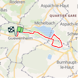
Guevenheim - Michelbach

regisbodilis
User

Length
11.2 km

Max alt
357 m

Uphill gradient
147 m
Km-Effort
13.2 km

Min alt
297 m

Downhill gradient
146 m
Boucle
Yes
Creation date :
2014-12-10 00:00:00.0
Updated on :
2014-12-10 00:00:00.0
2h51
Difficulty : Easy

FREE GPS app for hiking
 SityTrail
IGN / Geographical institutes
SityTrail Plus
The world is yours!
About
Trail Walking of 11.2 km to be discovered at Grand Est, Haut-Rhin, Guewenheim. This trail is proposed by regisbodilis.
Description
Guevenheim église - Lac Michelbach - retour église
Positioning
Country:
France
Region :
Grand Est
Department/Province :
Haut-Rhin
Municipality :
Guewenheim
Location:
Unknown
Start:(Dec)
Start:(UTM)
356731 ; 5290643 (32T) N.
Comments