


SityTrail - 2489713 - thann-roche--albert--grumbachkopf

argonneuweg
User

Length
7.6 km

Max alt
656 m

Uphill gradient
328 m
Km-Effort
12 km

Min alt
335 m

Downhill gradient
327 m
Boucle
Yes
Creation date :
2020-08-16 17:27:28.0
Updated on :
2020-08-24 17:15:37.611
2h28
Difficulty : Medium

FREE GPS app for hiking
 SityTrail
IGN / Geographical institutes
SityTrail Plus
The world is yours!
About
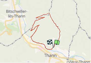
Trail Walking of 7.6 km to be discovered at Grand Est, Haut-Rhin, Thann. This trail is proposed by argonneuweg.
Description
Jolie balade ombragée avec beaux points de vue.
Positioning
Country:
France
Region :
Grand Est
Department/Province :
Haut-Rhin
Municipality :
Thann
Location:
Unknown
Start:(Dec)
Start:(UTM)
358084 ; 5297311 (32T) N.
Comments
Une bonne montée, puis une longue descente douce, le tout à l’ombre de la forêt. En résumé, très agréable. J’ai l’impression