


parking de Bellecombe- lacs de Lanserlia

laurentnecca
User
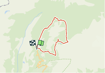

Length
12.5 km

Max alt
2773 m

Uphill gradient
541 m
Km-Effort
19.7 km

Min alt
2308 m

Downhill gradient
541 m
Boucle
Yes
Creation date :
2020-08-11 07:13:02.536
Updated on :
2020-08-18 04:06:48.632
4h52
Difficulty : Medium

FREE GPS app for hiking
 SityTrail
IGN / Geographical institutes
SityTrail Plus
The world is yours!
About
Trail Walking of 12.5 km to be discovered at Auvergne-Rhône-Alpes, Savoy, Val-Cenis. This trail is proposed by laurentnecca.
Positioning
Country:
France
Region :
Auvergne-Rhône-Alpes
Department/Province :
Savoy
Municipality :
Val-Cenis
Location:
Termignon
Start:(Dec)
Start:(UTM)
329910 ; 5021769 (32T) N.
Comments