


lac de miel-Beynat

joebartwix
User
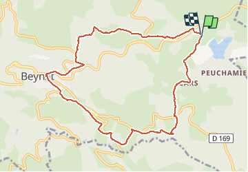

Length
10.5 km

Max alt
527 m

Uphill gradient
293 m
Km-Effort
14.4 km

Min alt
345 m

Downhill gradient
289 m
Boucle
Yes
Creation date :
2020-08-20 06:35:13.903
Updated on :
2020-08-20 09:06:21.255
2h00
Difficulty : Very easy
2h09
Difficulty : Very easy

FREE GPS app for hiking
 SityTrail
IGN / Geographical institutes
SityTrail Plus
The world is yours!
About
Trail Walking of 10.5 km to be discovered at New Aquitaine, Corrèze, Beynat. This trail is proposed by joebartwix.
Positioning
Country:
France
Region :
New Aquitaine
Department/Province :
Corrèze
Municipality :
Beynat
Location:
Unknown
Start:(Dec)
Start:(UTM)
402705 ; 4998301 (31T) N.
Comments