


Rando 4

Pascal Bernaud
User
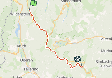

Length
18.1 km

Max alt
1420 m

Uphill gradient
653 m
Km-Effort
26 km

Min alt
1163 m

Downhill gradient
449 m
Boucle
No
Creation date :
2020-08-20 06:45:20.0
Updated on :
2020-08-20 12:50:41.047
6h03
Difficulty : Medium

FREE GPS app for hiking
 SityTrail
IGN / Geographical institutes
SityTrail Plus
The world is yours!
About
Trail Walking of 18.1 km to be discovered at Grand Est, Haut-Rhin, Metzeral. This trail is proposed by Pascal Bernaud.
Positioning
Country:
France
Region :
Grand Est
Department/Province :
Haut-Rhin
Municipality :
Metzeral
Location:
Unknown
Start:(Dec)
Start:(UTM)
349435 ; 5316519 (32T) N.
Comments