


12 lacs du carlit

pidjam
User
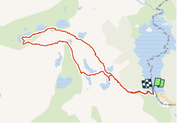

Length
11.2 km

Max alt
2353 m

Uphill gradient
372 m
Km-Effort
16.2 km

Min alt
2009 m

Downhill gradient
377 m
Boucle
Yes
Creation date :
2020-08-21 07:30:00.434
Updated on :
2020-08-21 12:45:01.507
4h29
Difficulty : Medium

FREE GPS app for hiking
 SityTrail
IGN / Geographical institutes
SityTrail Plus
The world is yours!
About
Trail Walking of 11.2 km to be discovered at Occitania, Pyrénées-Orientales, Angoustrine-Villeneuve-des-Escaldes. This trail is proposed by pidjam.
Positioning
Country:
France
Region :
Occitania
Department/Province :
Pyrénées-Orientales
Municipality :
Angoustrine-Villeneuve-des-Escaldes
Location:
Unknown
Start:(Dec)
Start:(UTM)
417849 ; 4712417 (31T) N.
Comments