


font romeu impro

pidjam
User
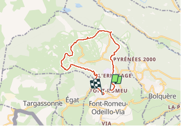

Length
13.9 km

Max alt
2129 m

Uphill gradient
425 m
Km-Effort
19.8 km

Min alt
1720 m

Downhill gradient
468 m
Boucle
No
Creation date :
2020-08-22 07:44:29.989
Updated on :
2020-08-22 12:29:33.688
4h12
Difficulty : Medium

FREE GPS app for hiking
 SityTrail
IGN / Geographical institutes
SityTrail Plus
The world is yours!
About
Trail Walking of 13.9 km to be discovered at Occitania, Pyrénées-Orientales, Font-Romeu-Odeillo-Via. This trail is proposed by pidjam.
Positioning
Country:
France
Region :
Occitania
Department/Province :
Pyrénées-Orientales
Municipality :
Font-Romeu-Odeillo-Via
Location:
Unknown
Start:(Dec)
Start:(UTM)
421358 ; 4706329 (31T) N.
Comments