


lacs et refuges de bellecombe

supercolas
User GUIDE
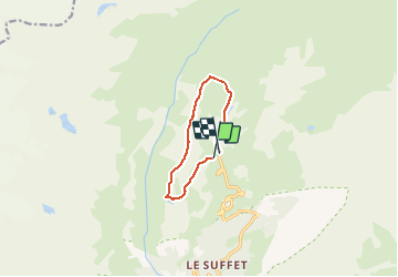

Length
7.9 km

Max alt
2445 m

Uphill gradient
273 m
Km-Effort
11.7 km

Min alt
2245 m

Downhill gradient
305 m
Boucle
Yes
Creation date :
2020-08-24 09:41:40.695
Updated on :
2020-08-24 15:47:47.322
3h37
Difficulty : Medium

FREE GPS app for hiking
 SityTrail
IGN / Geographical institutes
SityTrail Plus
The world is yours!
About
Trail Walking of 7.9 km to be discovered at Auvergne-Rhône-Alpes, Savoy, Val-Cenis. This trail is proposed by supercolas.
Description
Valcenis
Positioning
Country:
France
Region :
Auvergne-Rhône-Alpes
Department/Province :
Savoy
Municipality :
Val-Cenis
Location:
Termignon
Start:(Dec)
Start:(UTM)
329750 ; 5021609 (32T) N.
Comments