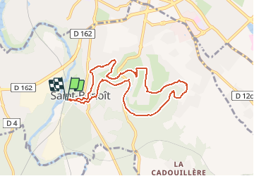
st Benoit : la médoquerie

laoj
User

Length
8.6 km

Max alt
123 m

Uphill gradient
139 m
Km-Effort
10.4 km

Min alt
76 m

Downhill gradient
139 m
Boucle
Yes
Creation date :
2020-08-25 09:50:42.345
Updated on :
2020-08-25 13:41:11.604
2h16
Difficulty : Medium

FREE GPS app for hiking
 SityTrail
IGN / Geographical institutes
SityTrail Plus
The world is yours!
About
Trail Walking of 8.6 km to be discovered at New Aquitaine, Vienne, Saint-Benoît. This trail is proposed by laoj.
Positioning
Country:
France
Region :
New Aquitaine
Department/Province :
Vienne
Municipality :
Saint-Benoît
Location:
Unknown
Start:(Dec)
Start:(UTM)
295872 ; 5158605 (31T) N.
Comments