


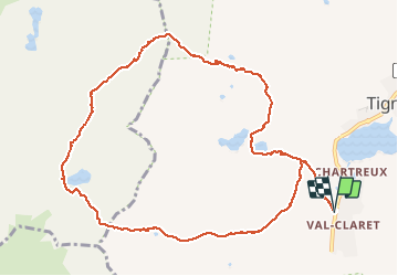
Valclaret col du Panet col de la Tourné lacs de Chardonnay Valclaret

psesjs
User

Length
12 km

Max alt
2660 m

Uphill gradient
748 m
Km-Effort
22 km

Min alt
2104 m

Downhill gradient
747 m
Boucle
Yes
Creation date :
2020-08-25 07:42:56.0
Updated on :
2020-08-25 14:50:43.198
4h08
Difficulty : Easy

FREE GPS app for hiking
 SityTrail
IGN / Geographical institutes
SityTrail Plus
The world is yours!
About
Trail Walking of 12 km to be discovered at Auvergne-Rhône-Alpes, Savoy, Tignes. This trail is proposed by psesjs.
Positioning
Country:
France
Region :
Auvergne-Rhône-Alpes
Department/Province :
Savoy
Municipality :
Tignes
Location:
Unknown
Start:(Dec)
Start:(UTM)
335700 ; 5035956 (32T) N.
Comments
Très joli tour, chouette. Dommage que la première heure soit sous les tire-fesses.