


Thannenkirch-Taennchel

JCLUTT
User
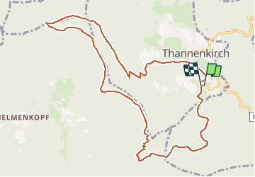

Length
11.2 km

Max alt
959 m

Uphill gradient
566 m
Km-Effort
18.8 km

Min alt
458 m

Downhill gradient
561 m
Boucle
Yes
Creation date :
2020-08-25 16:08:39.166
Updated on :
2020-08-25 16:18:45.787
3h50
Difficulty : Difficult

FREE GPS app for hiking
 SityTrail
IGN / Geographical institutes
SityTrail Plus
The world is yours!
About
Trail Walking of 11.2 km to be discovered at Grand Est, Haut-Rhin, Thannenkirch. This trail is proposed by JCLUTT.
Positioning
Country:
France
Region :
Grand Est
Department/Province :
Haut-Rhin
Municipality :
Thannenkirch
Location:
Unknown
Start:(Dec)
Start:(UTM)
374132 ; 5342913 (32U) N.
Comments