


73V Refuge aiguille arves départ Les Verneys

trietsch
User
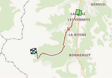

Length
7 km

Max alt
2251 m

Uphill gradient
728 m
Km-Effort
14.5 km

Min alt
1602 m

Downhill gradient
89 m
Boucle
No
Creation date :
2020-08-25 16:11:28.243
Updated on :
2020-08-25 16:12:20.253
3h14
Difficulty : Difficult

FREE GPS app for hiking
 SityTrail
IGN / Geographical institutes
SityTrail Plus
The world is yours!
About
Trail Walking of 7 km to be discovered at Auvergne-Rhône-Alpes, Savoy, Valloire. This trail is proposed by trietsch.
Positioning
Country:
France
Region :
Auvergne-Rhône-Alpes
Department/Province :
Savoy
Municipality :
Valloire
Location:
Unknown
Start:(Dec)
Start:(UTM)
296826 ; 5002698 (32T) N.
Comments