


20200826 Mantet-Allemany-..

ThonyM
User
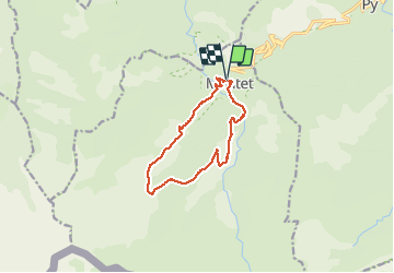

Length
12.4 km

Max alt
2115 m

Uphill gradient
713 m
Km-Effort
22 km

Min alt
1464 m

Downhill gradient
708 m
Boucle
Yes
Creation date :
2020-08-26 05:17:52.0
Updated on :
2020-08-26 10:58:05.864
4h09
Difficulty : Medium

FREE GPS app for hiking
 SityTrail
IGN / Geographical institutes
SityTrail Plus
The world is yours!
About
Trail Walking of 12.4 km to be discovered at Occitania, Pyrénées-Orientales, Mantet. This trail is proposed by ThonyM.
Description
Très belle boucle à la portée de tout bon marcheur
Photos


Positioning
Country:
France
Region :
Occitania
Department/Province :
Pyrénées-Orientales
Municipality :
Mantet
Location:
Unknown
Start:(Dec)
Start:(UTM)
442933 ; 4703096 (31T) N.
Comments