


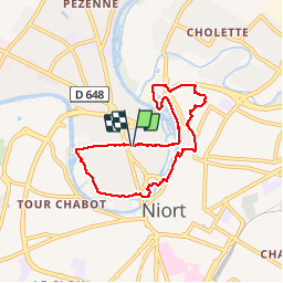
Niort_pré Leroy

olaze
User

Length
6.8 km

Max alt
51 m

Uphill gradient
69 m
Km-Effort
7.7 km

Min alt
7 m

Downhill gradient
68 m
Boucle
Yes
Creation date :
2014-12-10 00:00:00.0
Updated on :
2014-12-10 00:00:00.0
1h42
Difficulty : Easy

FREE GPS app for hiking
 SityTrail
IGN / Geographical institutes
SityTrail Plus
The world is yours!
About
Trail Walking of 6.8 km to be discovered at New Aquitaine, Deux-Sèvres, Niort. This trail is proposed by olaze.
Description
Départ & retour parking station Leclerc centre Niort.
Bords de Sèvres.Pré Leroy.Le Vivier.
Club rando Bessines *
Photos


Positioning
Country:
France
Region :
New Aquitaine
Department/Province :
Deux-Sèvres
Municipality :
Niort
Location:
Unknown
Start:(Dec)
Start:(UTM)
694775 ; 5133921 (30T) N.
Comments