


Lochberg ferme auberge

jmbilger
User
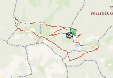

Length
12.5 km

Max alt
1027 m

Uphill gradient
415 m
Km-Effort
18.1 km

Min alt
732 m

Downhill gradient
434 m
Boucle
No
Creation date :
2020-08-27 08:25:36.0
Updated on :
2020-08-27 14:38:33.543
6h06
Difficulty : Very easy

FREE GPS app for hiking
 SityTrail
IGN / Geographical institutes
SityTrail Plus
The world is yours!
About
Trail Walking of 12.5 km to be discovered at Grand Est, Haut-Rhin, Kirchberg. This trail is proposed by jmbilger.
Photos


Positioning
Country:
France
Region :
Grand Est
Department/Province :
Haut-Rhin
Municipality :
Kirchberg
Location:
Unknown
Start:(Dec)
Start:(UTM)
344637 ; 5293911 (32T) N.
Comments