


Luppach-Grotte des Nains-Ruines du Château - Ferrette - Luppach

patrickbeyrath
User
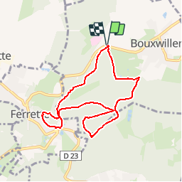

Length
7.8 km

Max alt
641 m

Uphill gradient
310 m
Km-Effort
11.9 km

Min alt
411 m

Downhill gradient
308 m
Boucle
Yes
Creation date :
2018-10-13 05:53:10.817
Updated on :
2018-10-13 05:53:10.837
2h30
Difficulty : Medium

FREE GPS app for hiking
 SityTrail
IGN / Geographical institutes
SityTrail Plus
The world is yours!
About
Trail Walking of 7.8 km to be discovered at Grand Est, Haut-Rhin, Bouxwiller. This trail is proposed by patrickbeyrath.
Positioning
Country:
France
Region :
Grand Est
Department/Province :
Haut-Rhin
Municipality :
Bouxwiller
Location:
Unknown
Start:(Dec)
Start:(UTM)
374462 ; 5262722 (32T) N.
Comments