Trail Walking Frontenac - La Commanderie de Sallebruneau  - Photo

La Commanderie de Sallebruneau

 Elbe
Elbe

User

© OpenStreetMap contributors
Length
Length
13.9 km
Max alt
Max alt
92 m
Uphill gradient
Uphill gradient
149 m
Km-Effort
Km-Effort  
15.8 km
Min alt
Min alt
31 m
Downhill gradient
Downhill gradient
147 m
Boucle
Boucle
Yes
Creation date :
2014-12-10 00:00:00.0
Updated on :
2014-12-10 00:00:00.0

(0 Reviews)

Walking
Walking
3h29
Difficulty : Very easy

Scan this QR Code to open this trail in the SityTrail application

FREE GPS app for hiking

Logo SityTrail SityTrail

IGN / Geographical institutes

Download SityTrail from the App Store Download SityTrail from Google Play

Logo SityTrail SityTrail World

The world is yours!

Download SityTrail from the App Store Download SityTrail from Google Play Download SityTrail on Huawei AppGallery

About

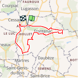
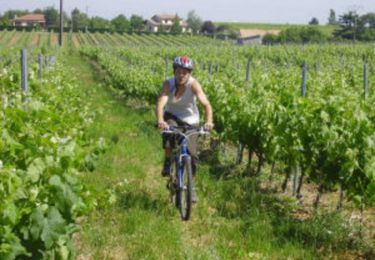
Trail Walking of 13.9 km to be discovered at New Aquitaine, Gironde, Frontenac. This trail is proposed by Elbe.

Description

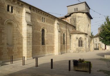
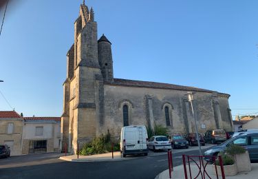
La commanderie de Sallebruneau se situe dans le département de la Gironde à une quarantaine de kilomètres au sud-est de Bordeaux, dans la région de l'Entre-deux-Mers, sur la commune de Frontenac. L'été, des spectacles ont lieu sur ce site, et des travaux de restauration devraient permettre un plus large accueil. Ainsi y a-t-il des chantiers de sauvegarde et de restauration, des stages de bénévoles (taille de pierre, jointoiement, relevés), et des visites guidées du site1. La chapelle saint Jean et des fortifications sont du XIIIe siècle, remaniées au XIVe. L'ensemble est placé sur une motte féodale. L'édifice est inscrit en totalité au titre des monuments historiques par arrêté du 22 décembre 1987.

Elevation profile

Positioning

Country:
France
Region :
New Aquitaine
Department/Province :
Gironde
Municipality :
Frontenac
Location:
Unknown
Start:(UTM)
724655 ; 4957802 (30T) N.

Trails nearby

Trail Bicycle tourism Courpiac - Courpiac -Mas d'Agenais - Photo
Bicycle tourism
ilur56

Bicycle tourism

Very difficult
Courpiac, New Aquitaine, Gironde, France
64 km | 74 km-effort
Unknown
No
Trail Walking Montignac - Boucle de Montignac - Photo
Walking
bedous

Walking

Easy
Montignac, New Aquitaine, Gironde, France
13.2 km | 15.1 km-effort
3h 25min
Yes
Trail Coupling Frontenac - Frontenac monté/attelé - Photo
Coupling
Shinkyy

Coupling

Medium
Frontenac, New Aquitaine, Gironde, France
13.3 km | 15.3 km-effort
2h 19min
Yes
Trail Walking Frontenac - Ballade de sainte presentine - Photo
Walking
dautriche

Walking

Very easy
Frontenac, New Aquitaine, Gironde, France
14.8 km | 16.6 km-effort
3h 54min
Yes
Trail Mountain bike Frontenac - Frontenac - ruisseaux et carrières - Photo
Mountain bike
tracegps

Mountain bike

Easy
Frontenac, New Aquitaine, Gironde, France
10.5 km | 12.2 km-effort
1h 30min
Yes
Trail Walking Frontenac - Frontenac - ruisseaux et carrières - Photo
Walking
tracegps

Walking

Easy
Frontenac, New Aquitaine, Gironde, France
10.5 km | 12.2 km-effort
3h 0min
Yes
Trail Walking Montignac - montignac - Photo
Walking
kienjo

Walking

Easy
Montignac, New Aquitaine, Gironde, France
50 km | 61 km-effort
3h 28min
No
Trail Walking Montignac - montignac  - Photo
Walking
jara

Walking

Difficult
Montignac, New Aquitaine, Gironde, France
11.4 km | 13.3 km-effort
3h 20min
Yes
Trail Walking Frontenac - Frontenac - Photo
Walking
domheitz

Walking

Easy
Frontenac, New Aquitaine, Gironde, France
75 km | 86 km-effort
7h 28min
No


Close
My subscriptions