


mont Ventoux sans le sommet

mthomas30
User
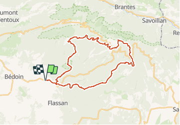

Length
37 km

Max alt
1616 m

Uphill gradient
1424 m
Km-Effort
56 km

Min alt
462 m

Downhill gradient
1425 m
Boucle
Yes
Creation date :
2020-08-30 06:16:01.927
Updated on :
2020-08-30 19:37:31.584
6h27
Difficulty : Medium

FREE GPS app for hiking
 SityTrail
IGN / Geographical institutes
SityTrail Plus
The world is yours!
About
Trail Mountain bike of 37 km to be discovered at Provence-Alpes-Côte d'Azur, Vaucluse, Bédoin. This trail is proposed by mthomas30.
Positioning
Country:
France
Region :
Provence-Alpes-Côte d'Azur
Department/Province :
Vaucluse
Municipality :
Bédoin
Location:
Unknown
Start:(Dec)
Start:(UTM)
678010 ; 4887631 (31T) N.
Comments