Trail Walking Mennetou-sur-Cher - MENNETOU - Photo
 cyberm
cyberm

User

© OpenStreetMap contributors
Length
Length
12 km
Max alt
Max alt
136 m
Uphill gradient
Uphill gradient
102 m
Km-Effort
Km-Effort  
13.3 km
Min alt
Min alt
87 m
Downhill gradient
Downhill gradient
102 m
Boucle
Boucle
Yes
Creation date :
2014-12-10 00:00:00.0
Updated on :
2014-12-10 00:00:00.0

(0 Reviews)

Walking
Walking
2h57
Difficulty : Easy

Scan this QR Code to open this trail in the SityTrail application

FREE GPS app for hiking

Logo SityTrail SityTrail

IGN / Geographical institutes

Download SityTrail from the App Store Download SityTrail from Google Play

Logo SityTrail SityTrail World

The world is yours!

Download SityTrail from the App Store Download SityTrail from Google Play Download SityTrail on Huawei AppGallery

About

Trail Walking of 12 km to be discovered at Centre-Loire Valley, Loir-et-Cher, Mennetou-sur-Cher. This trail is proposed by cyberm.

Description

Au pays de Thierry la Fronde

Elevation profile

Photos

Points of interest

Point of interest Mennetou-sur-Cher - 0000001 - Photo
cyberm
MENNETOU-SUR-CHER 
Point of interest Langon-sur-Cher - WPT_0000002 - Photo
cyberm
LANGON-SUR-CHER 
Point of interest Mennetou-sur-Cher - 0000003 - Photo
cyberm
MENNETOU-SUR-CHER 

Positioning

Country:
France
Region :
Centre-Loire Valley
Department/Province :
Loir-et-Cher
Municipality :
Mennetou-sur-Cher
Location:
Unknown
Start:(UTM)
414276 ; 5235553 (31T) N.

Trails nearby

Trail Walking Mennetou-sur-Cher - Entre forêt et manoirs, sur le chemin des Barres - Photo
Walking
Solognesud

Walking

Easy
(2)
Mennetou-sur-Cher, Centre-Loire Valley, Loir-et-Cher, France
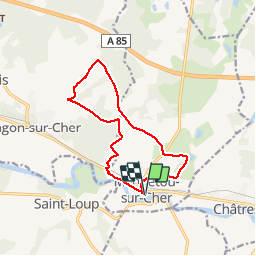
10.8 km | 12.1 km-effort
2h 42min
Yes
Trail Walking Mennetou-sur-Cher - Chemin du Briou - Mennetou-sur-Cher - Photo
Walking
tracegps

Walking

Easy
Mennetou-sur-Cher, Centre-Loire Valley, Loir-et-Cher, France
7.7 km | 8.7 km-effort
2h 0min
Yes
Trail Cycle Mennetou-sur-Cher - Entre Berry et Sologne - Photo
Cycle
Solognesud

Cycle

Easy
Mennetou-sur-Cher, Centre-Loire Valley, Loir-et-Cher, France
23 km | 25 km-effort
1h 29min
Yes
Trail Walking Mennetou-sur-Cher - mennetou sur cher - Photo
Walking
lecmic

Walking

Easy
Mennetou-sur-Cher, Centre-Loire Valley, Loir-et-Cher, France
19.6 km | 22 km-effort
3h 9min
Yes
Trail Walking Thénioux - thenioux - Photo
Walking
lecmic

Walking

Very easy
Thénioux, Centre-Loire Valley, Cher, France
12.3 km | 13.7 km-effort
3h 1min
Yes
Trail Walking Langon-sur-Cher - les etrils langon - Photo
Walking
lecmic

Walking

Very easy
Langon-sur-Cher, Centre-Loire Valley, Loir-et-Cher, France
14.3 km | 15.4 km-effort
2h 58min
Yes
Trail Walking Châtres-sur-Cher - la chatre sur cher - Photo
Walking
lecmic

Walking

Very easy
Châtres-sur-Cher, Centre-Loire Valley, Loir-et-Cher, France
17.6 km | 19.4 km-effort
2h 42min
Yes
Trail Walking Saint-Loup - rando saint loup - Photo
Walking
lecmic

Walking

Very easy
Saint-Loup, Centre-Loire Valley, Loir-et-Cher, France
12.3 km | 14 km-effort
2h 55min
Yes
Trail Walking Mennetou-sur-Cher - mennetou sur cher - Photo
Walking
lecmic

Walking

Easy
Mennetou-sur-Cher, Centre-Loire Valley, Loir-et-Cher, France
12.1 km | 13.2 km-effort
2h 40min
Yes


Close
My subscriptions