


Chateau et puech de Poujol

viam19
User
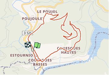

Length
6.6 km

Max alt
577 m

Uphill gradient
317 m
Km-Effort
10.8 km

Min alt
272 m

Downhill gradient
318 m
Boucle
Yes
Creation date :
2020-09-06 09:11:15.669
Updated on :
2020-09-18 14:16:41.571
3h46
Difficulty : Medium

FREE GPS app for hiking
 SityTrail
IGN / Geographical institutes
SityTrail Plus
The world is yours!
About
Trail Walking of 6.6 km to be discovered at Occitania, Aveyron, Saint-Hippolyte. This trail is proposed by viam19.
Description
Randonnée en boucle.
Attention au point d'intersection directionnel.
Photos


Positioning
Country:
France
Region :
Occitania
Department/Province :
Aveyron
Municipality :
Saint-Hippolyte
Location:
Unknown
Start:(Dec)
Start:(UTM)
465859 ; 4949374 (31T) N.
Comments