Trail Walking Saint-Hippolyte - Chateau et puech de Poujol - Photo

Chateau et puech de Poujol

 viam19
viam19

User

© OpenStreetMap contributors
Length
Length
6.6 km
Max alt
Max alt
577 m
Uphill gradient
Uphill gradient
317 m
Km-Effort
Km-Effort  
10.8 km
Min alt
Min alt
272 m
Downhill gradient
Downhill gradient
318 m
Boucle
Boucle
Yes
Creation date :
2020-09-06 09:11:15.669
Updated on :
2020-09-18 14:16:41.571

(0 Reviews)

Walking
Walking
3h46
Difficulty : Medium

Scan this QR Code to open this trail in the SityTrail application

FREE GPS app for hiking

Logo SityTrail SityTrail

IGN / Geographical institutes

Download SityTrail from the App Store Download SityTrail from Google Play

Logo SityTrail SityTrail World

The world is yours!

Download SityTrail from the App Store Download SityTrail from Google Play Download SityTrail on Huawei AppGallery

About

Trail Walking of 6.6 km to be discovered at Occitania, Aveyron, Saint-Hippolyte. This trail is proposed by viam19.

Description

Randonnée en boucle.
Attention au point d'intersection directionnel.

Elevation profile

Photos

Positioning

Country:
France
Region :
Occitania
Department/Province :
Aveyron
Municipality :
Saint-Hippolyte
Location:
Unknown
Start:(UTM)
465859 ; 4949374 (31T) N.

Trails nearby

Trail Mountain bike Murols - Le batut 1 - Photo
Mountain bike
Patrick Garcia

Mountain bike

Medium
Murols, Occitania, Aveyron, France
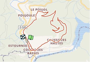
19.1 km | 30 km-effort
3h 18min
Yes
Trail Mountain bike Campouriez - Tour de couesque - Photo
Mountain bike
Max15

Mountain bike

Campouriez, Occitania, Aveyron, France
38 km | 57 km-effort
3h 5min
Yes
Trail Walking Entraygues-sur-Truyère - 12_ginolhac_crestes_2024 - Photo
Walking
jab31

Walking

Difficult
Entraygues-sur-Truyère, Occitania, Aveyron, France
18.2 km | 27 km-effort
6h 14min
No
Trail Walking Saint-Hippolyte - 2023-07-31_21h48m29_Cirkwi-La_retenue_de_Couesques - Photo
Walking
neoroll44

Walking

Very difficult
Saint-Hippolyte, Occitania, Aveyron, France
13.7 km | 20 km-effort
4h 35min
Yes
Trail Walking Le Fel - Le Fel - Photo
Walking
gcournac

Walking

Very difficult
Le Fel, Occitania, Aveyron, France
18 km | 27 km-effort
4h 42min
Yes
Trail Quad Murols - Murols(12)/Figeac(46) - Photo
Quad
O.R.

Quad

Very easy
Murols, Occitania, Aveyron, France
91 km | 117 km-effort
3h 43min
No
Trail Trail Montsalvy - étang de riol le mont - Photo
Trail
kayakiste15

Trail

Very easy
Montsalvy, Auvergne-Rhône-Alpes, Cantal, France
6.5 km | 9.9 km-effort
42min
No
Trail Running Le Fel - entre bel air et le viala - Photo
Running
kayakiste15

Running

Difficult
Le Fel, Occitania, Aveyron, France
38 km | 52 km-effort
3h 3min
No
Trail Mountain bike Campouriez - camin d olt sud couesque depuis passerelle  - Photo
Mountain bike
kayakiste15

Mountain bike

Difficult
Campouriez, Occitania, Aveyron, France
57 km | 83 km-effort
3h 56min
Yes


Close
My subscriptions