


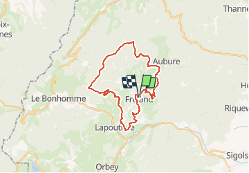
Tour de Fréland par Le Plat

duchaine.nicolas
User

Length
27 km

Max alt
1141 m

Uphill gradient
918 m
Km-Effort
39 km

Min alt
424 m

Downhill gradient
920 m
Boucle
Yes
Creation date :
2020-09-06 15:03:00.238
Updated on :
2020-09-07 14:04:54.067
1h56
Difficulty : Easy
1h56
Difficulty : Easy

FREE GPS app for hiking
 SityTrail
IGN / Geographical institutes
SityTrail Plus
The world is yours!
About
Trail Mountain bike of 27 km to be discovered at Grand Est, Haut-Rhin, Fréland. This trail is proposed by duchaine.nicolas.
Description
Ongrange - La Forêt - Chamont - Le Plat - Rehberg - Pierre des 3 Bans - Col de Fréland - Kalblin
Positioning
Country:
France
Region :
Grand Est
Department/Province :
Haut-Rhin
Municipality :
Fréland
Location:
Unknown
Start:(Dec)
Start:(UTM)
365793 ; 5337166 (32U) N.
Comments