


3 LACS-VOSGES SUD

surceneux
User
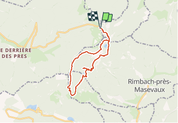

Length
12.6 km

Max alt
1157 m

Uphill gradient
606 m
Km-Effort
21 km

Min alt
816 m

Downhill gradient
613 m
Boucle
Yes
Creation date :
2020-09-06 09:36:37.297
Updated on :
2020-09-06 18:32:23.984
3h49
Difficulty : Medium

FREE GPS app for hiking
 SityTrail
IGN / Geographical institutes
SityTrail Plus
The world is yours!
About
Trail Walking of 12.6 km to be discovered at Grand Est, Haut-Rhin, Storckensohn. This trail is proposed by surceneux.
Description
DEPUIS ROUGE GAZON (ST MAURICE/MOSELLE)
COL DES PERCHES LAC- CHAUME HTE BERS -LACS : GRAND ET PETIT NEUWEIHER-GRRSSON - HT GRESSON - COL DES CHARBONNIERS - TETE DES PERCHES - ROUGE GAZON
Positioning
Country:
France
Region :
Grand Est
Department/Province :
Haut-Rhin
Municipality :
Storckensohn
Location:
Unknown
Start:(Dec)
Start:(UTM)
344292 ; 5302234 (32T) N.
Comments