


GR 10 - 1

loic09
User

Length
209 km

Max alt
1917 m

Uphill gradient
11465 m
Km-Effort
360 km

Min alt
0 m

Downhill gradient
10822 m
Boucle
No
Creation date :
2014-12-10 00:00:00.0
Updated on :
2014-12-10 00:00:00.0
69h26
Difficulty : Medium

FREE GPS app for hiking
 SityTrail
IGN / Geographical institutes
SityTrail Plus
The world is yours!
About
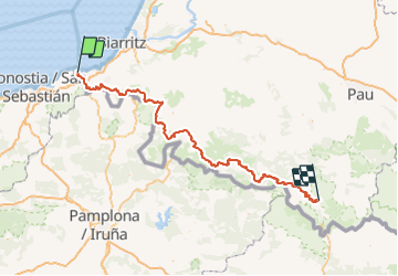
Trail Walking of 209 km to be discovered at New Aquitaine, Pyrénées-Atlantiques, Hendaye. This trail is proposed by loic09.
Description
D'Hendaye à Borce
Positioning
Country:
France
Region :
New Aquitaine
Department/Province :
Pyrénées-Atlantiques
Municipality :
Hendaye
Location:
Unknown
Start:(Dec)
Start:(UTM)
599307 ; 4802977 (30T) N.
Comments