


le chapeau de gendarme

bymarc26
User
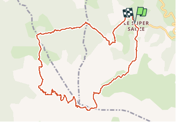

Length
13.8 km

Max alt
2659 m

Uphill gradient
1105 m
Km-Effort
29 km

Min alt
1689 m

Downhill gradient
1109 m
Boucle
Yes
Creation date :
2020-09-08 06:50:45.212
Updated on :
2020-09-08 13:31:46.143
4h30
Difficulty : Difficult

FREE GPS app for hiking
 SityTrail
IGN / Geographical institutes
SityTrail Plus
The world is yours!
About
Trail Walking of 13.8 km to be discovered at Provence-Alpes-Côte d'Azur, Alpes-de-Haute-Provence, Enchastrayes. This trail is proposed by bymarc26.
Positioning
Country:
France
Region :
Provence-Alpes-Côte d'Azur
Department/Province :
Alpes-de-Haute-Provence
Municipality :
Enchastrayes
Location:
Unknown
Start:(Dec)
Start:(UTM)
315528 ; 4914310 (32T) N.
Comments