


Col de la Roue Le Lavoir en boucle BS 2020 09 08

bstebe
User
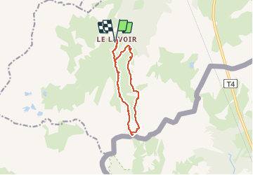

Length
11.6 km

Max alt
2554 m

Uphill gradient
654 m
Km-Effort
20 km

Min alt
1907 m

Downhill gradient
653 m
Boucle
Yes
Creation date :
2020-09-08 06:24:26.165
Updated on :
2020-09-08 15:38:45.995
4h40
Difficulty : Medium

FREE GPS app for hiking
 SityTrail
IGN / Geographical institutes
SityTrail Plus
The world is yours!
About
Trail Walking of 11.6 km to be discovered at Auvergne-Rhône-Alpes, Savoy, Modane. This trail is proposed by bstebe.
Description
Le Lavoir Col de la Roue route du Col du Fréjus Le Jeu Le Lavoir
Belle rando panoramique
Positioning
Country:
France
Region :
Auvergne-Rhône-Alpes
Department/Province :
Savoy
Municipality :
Modane
Location:
Unknown
Start:(Dec)
Start:(UTM)
314000 ; 5002159 (32T) N.
Comments