


SityTrail - Lièpvre Frankenbourg

vaillantjm
User
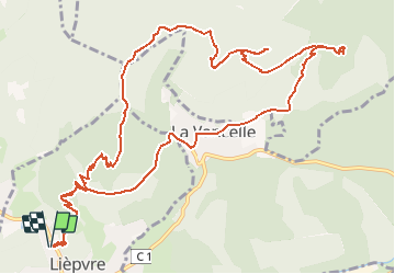

Length
14.7 km

Max alt
860 m

Uphill gradient
778 m
Km-Effort
25 km

Min alt
273 m

Downhill gradient
779 m
Boucle
Yes
Creation date :
2020-09-09 07:35:28.376
Updated on :
2020-09-16 07:09:36.325
5h15
Difficulty : Difficult

FREE GPS app for hiking
 SityTrail
IGN / Geographical institutes
SityTrail Plus
The world is yours!
About
Trail Walking of 14.7 km to be discovered at Grand Est, Haut-Rhin, Lièpvre. This trail is proposed by vaillantjm.
Positioning
Country:
France
Region :
Grand Est
Department/Province :
Haut-Rhin
Municipality :
Lièpvre
Location:
Unknown
Start:(Dec)
Start:(UTM)
372321 ; 5348288 (32U) N.
Comments