


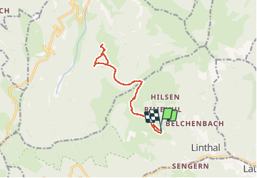
De l’Etterlematt à Landersen et retour

jmbilger
User

Length
12.6 km

Max alt
1132 m

Uphill gradient
517 m
Km-Effort
19.5 km

Min alt
844 m

Downhill gradient
525 m
Boucle
Yes
Creation date :
2020-09-10 08:53:20.0
Updated on :
2020-09-10 13:52:33.995
4h43
Difficulty : Unknown

FREE GPS app for hiking
 SityTrail
IGN / Geographical institutes
SityTrail Plus
The world is yours!
About
Trail Walking of 12.6 km to be discovered at Grand Est, Haut-Rhin, Linthal. This trail is proposed by jmbilger.
Photos


Positioning
Country:
France
Region :
Grand Est
Department/Province :
Haut-Rhin
Municipality :
Linthal
Location:
Unknown
Start:(Dec)
Start:(UTM)
358648 ; 5312866 (32T) N.
Comments