Trail Mountain bike Bébing - Bebing-Walscheid-Mont Ste Odile en VTT - Photo

Bebing-Walscheid-Mont Ste Odile en VTT

 bbazin
bbazin

User

© OpenStreetMap contributors
Length
Length
72 km
Max alt
Max alt
881 m
Uphill gradient
Uphill gradient
1993 m
Km-Effort
Km-Effort  
97 km
Min alt
Min alt
251 m
Downhill gradient
Downhill gradient
1511 m
Boucle
Boucle
No
Creation date :
2020-09-11 05:48:43.3
Updated on :
2021-06-24 08:50:04.043

(0 Reviews)

Mountain bike
Mountain bike
6h40
Difficulty : Difficult
Hybrid bike
Hybrid bike
6h40
Difficulty : Difficult

Scan this QR Code to open this trail in the SityTrail application

FREE GPS app for hiking

Logo SityTrail SityTrail

IGN / Geographical institutes

Download SityTrail from the App Store Download SityTrail from Google Play

Logo SityTrail SityTrail World

The world is yours!

Download SityTrail from the App Store Download SityTrail from Google Play Download SityTrail on Huawei AppGallery

About

Trail Mountain bike of 72 km to be discovered at Grand Est, Moselle, Bébing. This trail is proposed by bbazin.

Description

Randonnée effectuée en un peu plus de 8 heures 30 avec les pauses casse-croute et déjeuner, attention de bifurquer à Gensbourg pour se diriger vers  Lutzelhouse si non descendre par Niderhaslach  un peu plus long mais une côte en moins.La montée entre Mulbach et Grendelbruch est difficile par le sentier il vaut mieux rester sur la route.

Elevation profile

Positioning

Country:
France
Region :
Grand Est
Department/Province :
Moselle
Municipality :
Bébing
Location:
Unknown
Start:(UTM)
352659 ; 5397229 (32U) N.

Trails nearby

Trail Cycle Sarrebourg - Aux portes de Sarrebourg, le Pays des Grands Etangs - Sarrebourg - Circuit 20 - Photo
Cycle
tracegps

Cycle

Difficult
Sarrebourg, Grand Est, Moselle, France
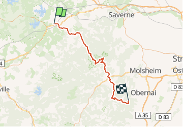
59 km | 69 km-effort
3h 30min
Yes
Trail Walking Lorquin - lorquin / roche au fées - Photo
Walking
Kuchly

Walking

Medium
Lorquin, Grand Est, Moselle, France
27 km | 35 km-effort
5h 55min
Yes
Trail Mountain bike Sarrebourg - Circuit VTT de Réding-Sarrebourg - Photo
Mountain bike
tracegps

Mountain bike

Difficult
Sarrebourg, Grand Est, Moselle, France
35 km | 42 km-effort
4h 0min
Yes
Trail Mountain bike Sarrebourg - Circuit VTT des Etangs de Rinting - Photo
Mountain bike
tracegps

Mountain bike

Difficult
Sarrebourg, Grand Est, Moselle, France
26 km | 31 km-effort
2h 30min
Yes
Trail Mountain bike Sarrebourg - Circuit VTT de la Vallée de la Sarre -Sarrebourg - Photo
Mountain bike
tracegps

Mountain bike

Medium
(1)
Sarrebourg, Grand Est, Moselle, France
18.9 km | 23 km-effort
1h 30min
Yes
Trail Mountain bike Sarrebourg - Circuit VTT de la Zone de Loisirs - Sarrebourg - Photo
Mountain bike
tracegps

Mountain bike

Easy
Sarrebourg, Grand Est, Moselle, France
4.6 km | 5.3 km-effort
30min
Yes
Trail Motorbike Sarrebourg - export-route-des-cretes-cols-vosgiens - Photo
Motorbike
HG74250

Motorbike

Very easy
Sarrebourg, Grand Est, Moselle, France
449 km | 571 km-effort
Unknown
No
Trail Bicycle tourism Hesse - Boucle Hesse - Abreschviller - Sarrebourg - Photo
Bicycle tourism
nfranche

Bicycle tourism

Medium
Hesse, Grand Est, Moselle, France
49 km | 56 km-effort
Unknown
Yes
Trail Cycle Hesse - piste cyclable, Alexis - Photo
Cycle
fredodlageo

Cycle

Easy
Hesse, Grand Est, Moselle, France
27 km | 31 km-effort
1h 45min
Yes


Close
My subscriptions