Trail Walking Villard-de-Lans - Balcon de la Bourne par le gros Martel - Photo

Balcon de la Bourne par le gros Martel

 pgeiger
pgeiger

User

© OpenStreetMap contributors
Length
Length
12.1 km
Max alt
Max alt
1551 m
Uphill gradient
Uphill gradient
677 m
Km-Effort
Km-Effort  
21 km
Min alt
Min alt
937 m
Downhill gradient
Downhill gradient
722 m
Boucle
Boucle
No
Creation date :
2020-09-11 08:51:12.0
Updated on :
2020-09-11 16:33:20.177

(0 Reviews)

Walking
Walking
5h48
Difficulty : Difficult

Scan this QR Code to open this trail in the SityTrail application

FREE GPS app for hiking

Logo SityTrail SityTrail

IGN / Geographical institutes

Download SityTrail from the App Store Download SityTrail from Google Play

Logo SityTrail SityTrail World

The world is yours!

Download SityTrail from the App Store Download SityTrail from Google Play Download SityTrail on Huawei AppGallery

About

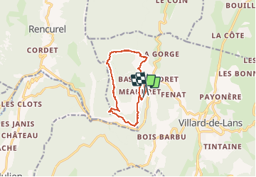
Trail Walking of 12.1 km to be discovered at Auvergne-Rhône-Alpes, Isère, Villard-de-Lans. This trail is proposed by pgeiger.

Description

Montée très forte jusqu’au gros Martel par un sentier mal identifié. Très beau balcon sur la Bourne

Elevation profile

Positioning

Country:
France
Region :
Auvergne-Rhône-Alpes
Department/Province :
Isère
Municipality :
Villard-de-Lans
Location:
Unknown
Start:(UTM)
698276 ; 4994845 (31T) N.

Trails nearby

Trail Snowshoes Autrans-Méaudre en Vercors - Le Gros Martel - Méaudre - Photo
Snowshoes
tracegps

Snowshoes

Medium
(4)
Autrans-Méaudre en Vercors, Auvergne-Rhône-Alpes, Isère, France
4.9 km | 8.4 km-effort
2h 10min
Yes
Trail Walking Villard-de-Lans - cabane de robon - Photo
Walking
Sylvie Mathiot

Walking

Very easy
(1)
Villard-de-Lans, Auvergne-Rhône-Alpes, Isère, France
10.2 km | 15.8 km-effort
5h 25min
Yes
Trail Walking Villard-de-Lans - Le sentier Peronnard et le Pas de l'OEille - Photo
Walking
tracegps

Walking

Easy
(1)
Villard-de-Lans, Auvergne-Rhône-Alpes, Isère, France
13.7 km | 25 km-effort
6h 0min
Yes
Trail Walking Villard-de-Lans - Le Plateau du Cornafion 1906m - Photo
Walking
tracegps

Walking

Difficult
(1)
Villard-de-Lans, Auvergne-Rhône-Alpes, Isère, France
7.8 km | 17.7 km-effort
4h 30min
Yes
Trail On foot Rencurel - La Balme Noire par la vire de Haute Valette - Photo
On foot
cmarit

On foot

Difficult
(1)
Rencurel, Auvergne-Rhône-Alpes, Isère, France
10.5 km | 21 km-effort
Unknown
Yes
Trail Mountain bike Villard-de-Lans - Villars de Lans Vières Les Cochettes Balcon de Villard Clot de la Balme Correncon - Photo
Mountain bike
GrouGary

Mountain bike

Medium
(1)
Villard-de-Lans, Auvergne-Rhône-Alpes, Isère, France
22 km | 32 km-effort
3h 31min
Yes
Trail Walking Villard-de-Lans - col_vert - Photo
Walking
vrolanta

Walking

Medium
(2)
Villard-de-Lans, Auvergne-Rhône-Alpes, Isère, France
8.7 km | 16.4 km-effort
3h 0min
Yes
Trail Walking Villard-de-Lans - Gorges de la Bourne - Photo
Walking
flyingdad

Walking

Easy
(5)
Villard-de-Lans, Auvergne-Rhône-Alpes, Isère, France
5.5 km | 8.8 km-effort
2h 13min
Yes
Trail Mountain bike Villard-de-Lans - La Royale (variante) - Photo
Mountain bike
flyingdad

Mountain bike

Medium
(1)
Villard-de-Lans, Auvergne-Rhône-Alpes, Isère, France
28 km | 37 km-effort
4h 0min
Yes


Close
My subscriptions