


pic de morres . roc lacalm

CASSISFRAMBOISE
User
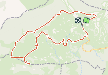

Length
14 km

Max alt
2214 m

Uphill gradient
389 m
Km-Effort
19.2 km

Min alt
1991 m

Downhill gradient
388 m
Boucle
Yes
Creation date :
2020-09-16 07:14:57.744
Updated on :
2020-09-16 12:25:24.834
4h17
Difficulty : Easy

FREE GPS app for hiking
 SityTrail
IGN / Geographical institutes
SityTrail Plus
The world is yours!
About
Trail Walking of 14 km to be discovered at Occitania, Pyrénées-Orientales, Font-Romeu-Odeillo-Via. This trail is proposed by CASSISFRAMBOISE.
Photos


Positioning
Country:
France
Region :
Occitania
Department/Province :
Pyrénées-Orientales
Municipality :
Font-Romeu-Odeillo-Via
Location:
Unknown
Start:(Dec)
Start:(UTM)
419585 ; 4708977 (31T) N.
Comments