


Collioure / Argeles

jwo47
User
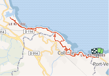

Length
13.8 km

Max alt
64 m

Uphill gradient
279 m
Km-Effort
17.5 km

Min alt
0 m

Downhill gradient
267 m
Boucle
Yes
Creation date :
2020-09-16 08:02:08.0
Updated on :
2020-09-16 13:45:20.762
4h16
Difficulty : Easy

FREE GPS app for hiking
 SityTrail
IGN / Geographical institutes
SityTrail Plus
The world is yours!
About
Trail Walking of 13.8 km to be discovered at Occitania, Pyrénées-Orientales, Port-Vendres. This trail is proposed by jwo47.
Description
Collioure / Argeles
Positioning
Country:
France
Region :
Occitania
Department/Province :
Pyrénées-Orientales
Municipality :
Port-Vendres
Location:
Unknown
Start:(Dec)
Start:(UTM)
508187 ; 4707872 (31T) N.
Comments