


arve

Liebeaux
User
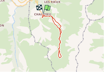

Length
13.2 km

Max alt
2288 m

Uphill gradient
703 m
Km-Effort
23 km

Min alt
1582 m

Downhill gradient
702 m
Boucle
Yes
Creation date :
2020-09-17 07:40:45.274
Updated on :
2020-09-17 13:41:50.547
5h59
Difficulty : Very easy

FREE GPS app for hiking
 SityTrail
IGN / Geographical institutes
SityTrail Plus
The world is yours!
About
Trail Walking of 13.2 km to be discovered at Auvergne-Rhône-Alpes, Savoy, Albiez-Montrond. This trail is proposed by Liebeaux.
Positioning
Country:
France
Region :
Auvergne-Rhône-Alpes
Department/Province :
Savoy
Municipality :
Albiez-Montrond
Location:
Unknown
Start:(Dec)
Start:(UTM)
289315 ; 5007034 (32T) N.
Comments