


Saint Génies 19-09-2020

robinier
User
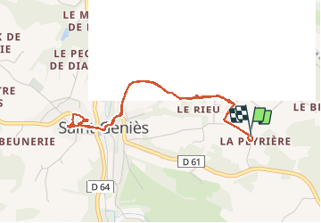

Length
4.5 km

Max alt
251 m

Uphill gradient
88 m
Km-Effort
5.7 km

Min alt
194 m

Downhill gradient
89 m
Boucle
Yes
Creation date :
2020-09-19 15:36:32.0
Updated on :
2020-09-19 17:37:39.583
2h01
Difficulty : Unknown

FREE GPS app for hiking
 SityTrail
IGN / Geographical institutes
SityTrail Plus
The world is yours!
About
Trail Walking of 4.5 km to be discovered at New Aquitaine, Dordogne, Saint-Geniès. This trail is proposed by robinier.
Photos


Positioning
Country:
France
Region :
New Aquitaine
Department/Province :
Dordogne
Municipality :
Saint-Geniès
Location:
Unknown
Start:(Dec)
Start:(UTM)
363477 ; 4983677 (31T) N.
Comments