


HATTSTATT

jcschubnel
User
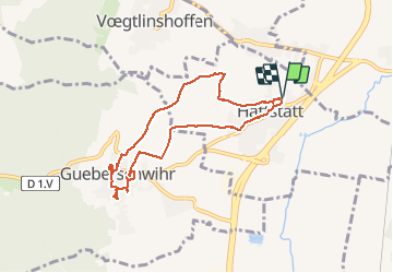

Length
7.3 km

Max alt
275 m

Uphill gradient
121 m
Km-Effort
9 km

Min alt
197 m

Downhill gradient
123 m
Boucle
Yes
Creation date :
2020-08-29 12:01:38.546
Updated on :
2020-09-20 16:06:31.003
2h34
Difficulty : Very easy

FREE GPS app for hiking
 SityTrail
IGN / Geographical institutes
SityTrail Plus
The world is yours!
About
Trail Walking of 7.3 km to be discovered at Grand Est, Haut-Rhin, Hattstatt. This trail is proposed by jcschubnel.
Positioning
Country:
France
Region :
Grand Est
Department/Province :
Haut-Rhin
Municipality :
Hattstatt
Location:
Unknown
Start:(Dec)
Start:(UTM)
373379 ; 5319053 (32U) N.
Comments