Trail Walking Saignon - Saignon - Apt - Photo
 LtZIP
LtZIP

User

© OpenStreetMap contributors
Length
Length
9.3 km
Max alt
Max alt
494 m
Uphill gradient
Uphill gradient
289 m
Km-Effort
Km-Effort  
13.2 km
Min alt
Min alt
223 m
Downhill gradient
Downhill gradient
289 m
Boucle
Boucle
Yes
Creation date :
2020-09-21 09:40:39.933
Updated on :
2021-02-11 07:52:55.018

(1 Reviews)

Walking
Walking
4h37
Difficulty : Easy

Scan this QR Code to open this trail in the SityTrail application

FREE GPS app for hiking

Logo SityTrail SityTrail

IGN / Geographical institutes

Download SityTrail from the App Store Download SityTrail from Google Play

Logo SityTrail SityTrail World

The world is yours!

Download SityTrail from the App Store Download SityTrail from Google Play Download SityTrail on Huawei AppGallery

About

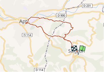
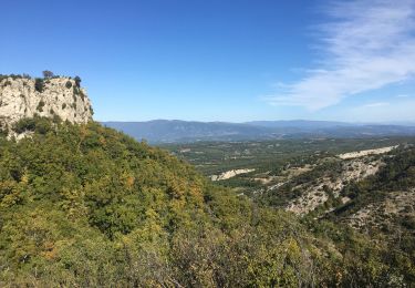
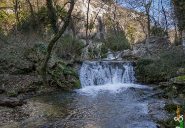
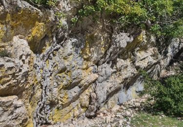
Trail Walking of 9.3 km to be discovered at Provence-Alpes-Côte d'Azur, Vaucluse, Saignon. This trail is proposed by LtZIP.

Description

IBP : Bleu - 39
Circuit sans intérêt car empruntant trop souvent des routes.

Elevation profile

Photos

Positioning

Country:
France
Region :
Provence-Alpes-Côte d'Azur
Department/Province :
Vaucluse
Municipality :
Saignon
Location:
Unknown
Start:(UTM)
695278 ; 4859340 (31T) N.

Comments

Please log in to post a review or rate the element


Trails nearby

Trail Cycle Apt - Les Ocres à vélo - Photo
Cycle
GUIDE+

Cycle

Medium
(4)
Apt, Provence-Alpes-Côte d'Azur, Vaucluse, France
51 km | 61 km-effort
3h 31min
Yes
Trail Walking Saignon - Saignon  Bories - Photo
Walking
kephas

Walking

Easy
(2)
Saignon, Provence-Alpes-Côte d'Azur, Vaucluse, France
10.8 km | 13.8 km-effort
3h 2min
Yes
Trail Walking Buoux - Plateau des Claparèdes - Saignon - Photo
Walking
tracegps

Walking

Medium
(1)
Buoux, Provence-Alpes-Côte d'Azur, Vaucluse, France
10.8 km | 14.6 km-effort
5h 0min
Yes
Trail Cycle Apt - Circuit Vélo - Les Ocres en vélo - Apt - Photo
Cycle
tracegps

Cycle

Difficult
(1)
Apt, Provence-Alpes-Côte d'Azur, Vaucluse, France
50 km | 60 km-effort
5h 0min
Yes
Trail Walking Sivergues - Sivergues - Photo
Walking
lviallet

Walking

Medium
(1)
Sivergues, Provence-Alpes-Côte d'Azur, Vaucluse, France
9.8 km | 16.2 km-effort
3h 35min
Yes
Trail Walking Buoux - Circuit de l'Aigue Brun - Buoux - Photo
Walking
tracegps

Walking

Easy
(3)
Buoux, Provence-Alpes-Côte d'Azur, Vaucluse, France
11.8 km | 17 km-effort
4h 15min
Yes
Trail Walking Buoux - 2024-03-15 Buoux - Sivergues - Photo
Walking
GUIDE
Kargil

Walking

Difficult
Buoux, Provence-Alpes-Côte d'Azur, Vaucluse, France
16.7 km | 25 km-effort
5h 42min
Yes
Trail Walking Buoux - L'Aiguebrun Sivergues - Photo
Walking
GUIDE
amiral13

Walking

Very easy
(1)
Buoux, Provence-Alpes-Côte d'Azur, Vaucluse, France
8 km | 10.8 km-effort
6h 20min
Yes
Trail Walking Auribeau - Le Mourre Nègre - Photo
Walking
makounet

Walking

Medium
(1)
Auribeau, Provence-Alpes-Côte d'Azur, Vaucluse, France
16.1 km | 27 km-effort
5h 31min
Yes


Close
My subscriptions