Trail Cycle Apt - Circuit Vélo - Les Ocres en vélo - Apt - Photo

Circuit Vélo - Les Ocres en vélo - Apt

 tracegps
tracegps

User

© OpenStreetMap contributors
Length
Length
50 km
Max alt
Max alt
416 m
Uphill gradient
Uphill gradient
743 m
Km-Effort
Km-Effort  
60 km
Min alt
Min alt
215 m
Downhill gradient
Downhill gradient
744 m
Boucle
Boucle
Yes
Creation date :
2014-12-10 00:00:00.0
Updated on :
2014-12-10 00:00:00.0

(1 Reviews)

Cycle
Cycle
5h00
Difficulty : Difficult

Scan this QR Code to open this trail in the SityTrail application

FREE GPS app for hiking

Logo SityTrail SityTrail

IGN / Geographical institutes

Download SityTrail from the App Store Download SityTrail from Google Play

Logo SityTrail SityTrail World

The world is yours!

Download SityTrail from the App Store Download SityTrail from Google Play Download SityTrail on Huawei AppGallery

About

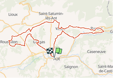
Trail Cycle of 50 km to be discovered at Provence-Alpes-Côte d'Azur, Vaucluse, Apt. This trail is proposed by tracegps.

Description

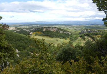
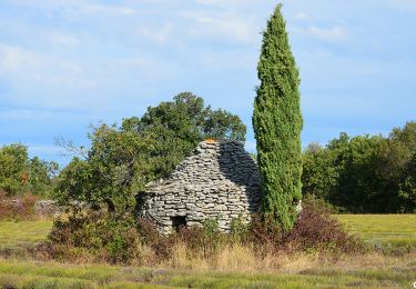
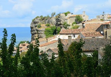
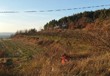
Par de petites routes pittoresques et peu fréquentées, cet itinéraire, accessible à tous, traverse quelques-uns des plus beaux paysages et des villages les plus remarquables du parc naturel régional. Terre de matières et de couleurs où la lumière joue les contrastes des saisons, vous parcourrez des sites naturels exceptionnels : les gisements d’ocre du Luberon. Laissez-vous imprégner par la beauté magique de ces lieux. Bonne Balade !... Départ de Apt. Retrouvez plus d’informations et téléchargez la fiche du circuit sur le site de la Provence en vélo.

Elevation profile

Photos

Positioning

Country:
France
Region :
Provence-Alpes-Côte d'Azur
Department/Province :
Vaucluse
Municipality :
Apt
Location:
Unknown
Start:(UTM)
692191 ; 4860993 (31T) N.

Comments

Please log in to post a review or rate the element


Bien. Le fléchage pourrait être in peu mieux adapté. Surtout à Apt


Trails nearby

Trail Cycle Apt - Les Ocres à vélo - Photo
Cycle
GUIDE+

Cycle

Medium
(4)
Apt, Provence-Alpes-Côte d'Azur, Vaucluse, France
51 km | 61 km-effort
3h 31min
Yes
Trail Walking Saignon - Saignon  Bories - Photo
Walking
kephas

Walking

Easy
(2)
Saignon, Provence-Alpes-Côte d'Azur, Vaucluse, France
10.8 km | 13.8 km-effort
3h 2min
Yes
Trail Walking Buoux - Plateau des Claparèdes - Saignon - Photo
Walking
tracegps

Walking

Medium
(1)
Buoux, Provence-Alpes-Côte d'Azur, Vaucluse, France
10.8 km | 14.6 km-effort
5h 0min
Yes
Trail Walking Buoux - Buoux /Saignon - Photo
Walking
FLORENSAC

Walking

Difficult
Buoux, Provence-Alpes-Côte d'Azur, Vaucluse, France
12.4 km | 15.6 km-effort
5h 45min
Yes
Trail Walking Apt - CR_Domitia_BE_25_Apt_Cereste_20220407 - Photo
Walking
patrickdanilo

Walking

Medium
Apt, Provence-Alpes-Côte d'Azur, Vaucluse, France
21 km | 29 km-effort
5h 54min
No
Trail Walking Buoux - SityTrail - 2428982 - grp-luberon-tour-des-clapaedes-42km - Photo
Walking
GUIDE
thonyc

Walking

Difficult
Buoux, Provence-Alpes-Côte d'Azur, Vaucluse, France
17.7 km | 23 km-effort
5h 40min
Yes
Trail Walking Saignon - Saignon - Circuit des Bories - Photo
Walking
LtZIP

Walking

Easy
Saignon, Provence-Alpes-Côte d'Azur, Vaucluse, France
9.4 km | 12.1 km-effort
3h 58min
Yes
Trail Walking Saignon - Saignon - Apt - Photo
Walking
LtZIP

Walking

Easy
(1)
Saignon, Provence-Alpes-Côte d'Azur, Vaucluse, France
9.3 km | 13.2 km-effort
4h 37min
Yes
Trail Walking Bonnieux - Roquemaure  - Photo
Walking
POMMEN

Walking

Easy
Bonnieux, Provence-Alpes-Côte d'Azur, Vaucluse, France
5.3 km | 7.5 km-effort
1h 31min
Yes


Close
My subscriptions