


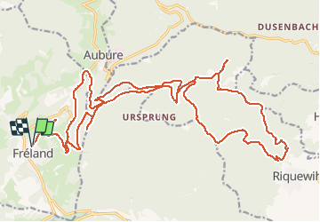
Fréland Riquewihr

duchaine.nicolas
User

Length
32 km

Max alt
940 m

Uphill gradient
1224 m
Km-Effort
48 km

Min alt
348 m

Downhill gradient
1226 m
Boucle
Yes
Creation date :
2020-09-22 07:37:09.98
Updated on :
2020-09-22 18:50:42.951
2h55
Difficulty : Easy
2h55
Difficulty : Easy

FREE GPS app for hiking
 SityTrail
IGN / Geographical institutes
SityTrail Plus
The world is yours!
About
Trail Mountain bike of 32 km to be discovered at Grand Est, Haut-Rhin, Fréland. This trail is proposed by duchaine.nicolas.
Description
Via Col de Fréland, Rocher du Tétras, Koenigsstuhl, Col du Seelacker, Riquewihr
Positioning
Country:
France
Region :
Grand Est
Department/Province :
Haut-Rhin
Municipality :
Fréland
Location:
Unknown
Start:(Dec)
Start:(UTM)
365794 ; 5337176 (32U) N.
Comments