


col de la gardette par la piste

orsel
User GUIDE
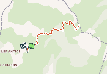

Length
9.4 km

Max alt
2120 m

Uphill gradient
657 m
Km-Effort
18.1 km

Min alt
1455 m

Downhill gradient
655 m
Boucle
Yes
Creation date :
2020-09-23 07:19:17.769
Updated on :
2020-09-24 06:14:00.561
3h03
Difficulty : Very easy

FREE GPS app for hiking
 SityTrail
IGN / Geographical institutes
SityTrail Plus
The world is yours!
About
Trail Walking of 9.4 km to be discovered at Provence-Alpes-Côte d'Azur, Hautes-Alpes, Chorges. This trail is proposed by orsel.
Positioning
Country:
France
Region :
Provence-Alpes-Côte d'Azur
Department/Province :
Hautes-Alpes
Municipality :
Chorges
Location:
Unknown
Start:(Dec)
Start:(UTM)
283917 ; 4939520 (32T) N.
Comments