


La Grave 12

Airelle
User

Length
26 km

Max alt
2478 m

Uphill gradient
1127 m
Km-Effort
41 km

Min alt
1490 m

Downhill gradient
1081 m
Boucle
No
Creation date :
2020-09-30 08:38:24.0
Updated on :
2020-09-30 15:38:37.839
5h51
Difficulty : Unknown

FREE GPS app for hiking
 SityTrail
IGN / Geographical institutes
SityTrail Plus
The world is yours!
About
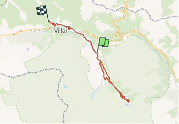
Trail Walking of 26 km to be discovered at Provence-Alpes-Côte d'Azur, Hautes-Alpes, Villar-d'Arêne. This trail is proposed by Airelle.
Positioning
Country:
France
Region :
Provence-Alpes-Côte d'Azur
Department/Province :
Hautes-Alpes
Municipality :
Villar-d'Arêne
Location:
Unknown
Start:(Dec)
Start:(UTM)
292876 ; 4988541 (32T) N.
Comments