


Fréland - Aubure - Taenchel

duchaine.nicolas
User
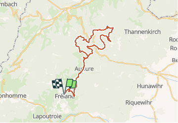

Length
34 km

Max alt
992 m

Uphill gradient
1208 m
Km-Effort
50 km

Min alt
490 m

Downhill gradient
1206 m
Boucle
Yes
Creation date :
2020-10-04 08:22:26.356
Updated on :
2020-10-04 13:10:29.46
4h05
Difficulty : Medium
4h05
Difficulty : Medium

FREE GPS app for hiking
 SityTrail
IGN / Geographical institutes
SityTrail Plus
The world is yours!
About
Trail Mountain bike of 34 km to be discovered at Grand Est, Haut-Rhin, Fréland. This trail is proposed by duchaine.nicolas.
Positioning
Country:
France
Region :
Grand Est
Department/Province :
Haut-Rhin
Municipality :
Fréland
Location:
Unknown
Start:(Dec)
Start:(UTM)
365795 ; 5337173 (32U) N.
Comments